
February 8 and 9, 2018
~20 miles
Bob and I have been trying to get to the Sampson Mountain Wilderness in Tennessee near Erwin but this was the only window in February that I had and the cold and rainy weather was not going to allow enough time to do it justice so we decided to just do an overnight somewhere closer.
For years we had driven by the South Mountains on the way to somewhere else and dismissed them as trivial hills but I looked closer at the park and realized that there were a lot of trails and quite a bit of steep country. We decided to give it a try and Bob brilliantly invited David Swanson who had done the master plan for the park to come along, he jumped at the trip and gave us full insight into the park.
Barely a 3 hour drive we arrived at the visitor center at 8:30 and visited with the Park Superintendent that David had worked with before starting at the horse trailer parking lot and heading out on the Saddleback trail with temps in the 40’s. Almost immediately we had to wade across Jacob Fork creek, it was cold and fast moving but we were able to use the big rocks, just barely submerged, to make our way across.

Just across the creek we intersected with a side trail that David said came from the horse camping area and there was a bridge across the creek there, wished he had told us that earlier.
Our general plan was to gain the ridge and walk around the top of the watershed for Jacob Creek. Most of the trails are on old forest roads with a few single track sections. Our route is in red in the map below. Here is the map at the State Park site.

After 3 miles of well graded trail we topped out on the ridge that separates the park from a development to the southeast. You have to walk a paved road for a few miles to Benn Knob at just under 2900′, the highest point in the area. We stopped part way across for lunch, just down the Fox trail about 100 yards, at a great view looking north towards Grandfather Mountain.

Benn Knob has a radio tower and is fenced in so we skirted around below the very top and picked up the Benn Knob trail which is an old road with some views off both sides. It was warming up nicely and we took a long break, I am pretty sure I heard snoring.

The trail turns into the Lower CCC trail as it heads north and after a few miles we arrived at the other end of the Fox trail that cuts down and back up across the watershed. Down it a quarter mile or so are the Fox Trail campsites in a nice open meadow with a good water source down in the hollow at the bottom of the field. We pull in early, for us, at 4:30 but after 10 miles. You have to camp at the few designated sites and this was our best bet. We had seen no other people all day.
The usual wood and water gathering followed buy brown liquor enjoyed around the fire with of course, the perfect food. We laid our bags out in the field to enjoy the very clear sky.
It dropped to 27 degrees at one point but the next morning we woke to 31 degrees and sunny skies. We had a fine breakfast and then continued around the rim.

Where the Lower CCC trail intersects the Upper Falls trail it then turns into the Horseridge trail where it takes a steep climb up to the site of the old Horse Ridge fire tower at 2600′, now gone, but with a great view north towards Hawksbill, Table Rock, Big Bald and Roan Mountain way out there.

The old road curves east and when we hit the Possum trail we decide instead of continuing to follow the road and ridge we would drop down the single track hiker trail to the parks signature feature High Shoals Falls.
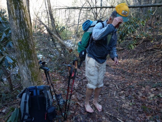
The Possum trail drops steeply down to Shinny Creek with some of the side hills just about as steep as you can get without being a cliff. We hit Shinny Creek and have to take the shoes off again to wade across.

Bob thinks maybe he will walk the rest of the way barefoot.
Where Shinny Creek hits Jacob Fork we turned up stream to go see the falls and run into our first people in 2 days. Quite a walk up to the falls with several bridges, lots of steps and rocks. You can see the final 80 foot drop way at the top.

The big drop is quite a show

As we headed back down stream lots of people were coming in. We tied together a few different trails and one section of road walking to get back to the car by about 11:00 after another 10 miles or so. Great short trip and there are more trails to explore here.
