Pictographs, Poets, Posts, Planets and Perambulations
Feb. 15-21, 2024
~27 miles as day hikes
Just as I got home from my December trip with Robert and Scott, I naturally started to think about next years trip to the Bend. One of the things that had intrigued me for some years was the Lonestar Cowboy Poetry Gathering held in February, in Alpine Texas, at Sul Ross State Univ. and I figured I could work a trip around that at some point. Southwest Airlines was sending me notices of really cheap flights and Betsy said I should go this February. So for the first time ever I returned to West Texas twice in one winter. This is the first time I have posted a report that did not involve backpacking. Originally I had planned on a few nights in the backcountry but changed it to day hikes instead and thought I should still write up a report and post it here as it does have some distinct Big Bend National Park walks.
I flew in late afternoon to San Antonio, got a rental car and made it to the hotel for the night. Up and on the road super early to both beat the SA traffic and to get to Seminole Canyon State Park by 10:00 for the Fate Bell Shelter tour. I like to sometimes go out to, or back from, the park on US 90, for different views and places and take I-10 the other direction, the driving time is essentially the same.
Seminole Canyon is right on US 90 and about half way to Alpine or the park and makes a good stop for a leg stretch if nothing else. Known for it’s rock art in big alcove shelters you have to take one of the tours to be able to see it, some are only offered in certain seasons but the Fate Bell tour is offered once or twice a day and only takes 1.5 hours. I arrived in time to take in their good museum/visitor center before 20 of us headed down into the canyon with the guide. This is looking up canyon to another alcove.
This awesome statue is the symbol of the park and modeled after some of the pictographs. It was an overcast day, perfect for hiking into this potentially hot canyon.
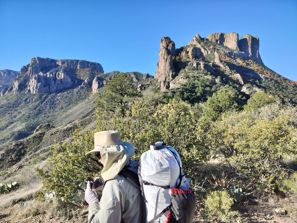
My 20th backpacking trip to Big Bend in the 50th year of my explorations of the area was a bit different and as usual, intended for us to delve into areas we had never been in before. There would be three of us with Robert and Scott. Scott was coming out of too many hours behind a desk in Washington DC and so of the several options I had drawn up I chose one that I thought would be a little bit easier walking but there were a few cruxes, Robert concurred. On paper, of the 60 miles, there would be 10 on real trails and another 20 or so on old roads and powerline track with not a ton of elevation gain/loss other than the first and last days, should be pretty easy, right? My thoughts were not exactly correct.
I call it the Northeast Chisos loop because it starts by dropping out of the Chisos Basin in an easterly direction by an unusual route and then heads northeast toward Tornillo Creek, go upstream for a while before starting back southwesterly and then winding our way around the northern and western flanks of the Chisos finally climbing back up into the Basin via the Oak Spring and Windows trail. You can see the map here. It checks off a number of places Robert and I had never seen before and of course we would be hunting for springs on the map as well.
The route crossed a paved road three times which allowed for liberal use of caches to make for even lighter packs. In the end we dropped one water cache and two water and food caches using 5 bear canisters. We counted on water in Tornillo creek and several springs around the base of the Chisos to augment what we dropped in advance. That plan worked beautifully. Going in the weather forecast was nearly ideal, 60’s and 30’s with a slight chance of rain the last 2 days, we did have a few surprises.
As usual I flew into San Antonio late Wednesday afternoon and Scott met me at baggage claim, everything arrived with no issues. We took the shuttle to the hotel and then Ubered to downtown to check out our first BBQ place, Pinkertons, which was in Texas Monthly’s latest Top 50 list. Excellent. Back to the room for an early night.
Robert rolled in at 6:00 a.m. to pick us up and we headed west to Boerne for the excellent breakfast tacos at Marys and to pick up a few things at HEB that Scott needed. A few more stops on the way and we rolled into the park around 1:30 and stopped at the Fossil Bone Exhibit to prepare our caches. It took a surprisingly long time to organize our food and water between the 5 bear canisters but finally got it all done. We drove across the Tornillo creek bridge and hid one there to be picked up the third day.
On up to Panther Junction for our permit and I was a bit more anxious than usual about the process. Just a few weeks before we got there a young girl was lost for a week on the Lost Mine trail (LMT) which is where we were going to start and I was nervous about how we would negotiate the permit writing and not tell them that was where we were also going to begin, figuring that they would be extra sensitive about anything off trail in that area. In the end it was all good and they were somewhat amazed at the miles we were going to do. Another first, they asked if we had a satellite communication device and I said I did and they wanted the contact number, I had brought it just in case they asked, particularly because we were going to go in through Pine canyon, not because I thought we might need it for this trip.
Afterwards we dropped our other two caches and headed to the Chisos Mining Co. Motel to finish our packing for the trip. Off to the Starlight Theater for dinner and to bed for an early start.
Trail Day 1
Rolling at 6:00 we made the 45 minute drive up to the Basin lodge for breakfast just as they opened and to meet an acquaintance from Big Bend Chat that was going to help with the small but time consuming shuttle from the Amphitheater, where backpackers leave their vehicles, to the LMT. We had a great visit but had to pull ourselves away as we knew this was going to be a long, hard day and needed all the time we could get.
Finally on the trail just before 9:00 we took our time on the thousand plus foot climb to the top, it was a brilliant day.
Ran up to Mt. Rogers/Grayson Highlands the end of April to try and catch the Lyrid meteor shower after a big, rainy, front had rolled through and cleared the skies. It was indeed the clearest I had ever seen it up there. It was also the first time I had been back to backpack the area in 20 years. Rolled in at 1:30 to the backpackers parking lot at Grayson Highlands State Park, you have to reserve a spot online now, by at least the day before, $15 a night and you can’t enter before 1:00 p.m., which Bob would definitely not go for.
On the trail by 2:00 heading north on the AT. Got to Bob’s favorite, the Yuppie shelter (Wise) and there was a thru hiker there that said he had started in mid February but had to take a few weeks off with a sprained ankle. He headed out before me as I took a break. I was surprised when I easily caught him not too far down the trail as I figured he would certainly be in better shape and moving faster than me.
Did a modified, reverse, Bob loop and went down the Bear Pen trail but didn’t take the Kabel trail so did not check on the Viking Settlement. I wanted to go on down the Bear Pen trail, which still has the sign that says “deep mud, travel not recommended” to see what that was all about. Not bad at all, a few places with streams flowing down the trail. Caught the First Peak trail at the gap between First and Second Peaks. Up the climb to Second Peak and then over to Third and finally out into the open areas on Stone mountain. 6:00, 7.5 miles. The views were excellent, clear, with a firm breeze. A perfect spot to layout and look for meteors! Looking west towards Mt. Rogers and Wilburn Ridge.
A half a century ago, this week, we rolled into Big Bend for the first time
April 15-22, 1973
One from the wayback machine with photos from slides I finally scanned, quality is not great but tells the story along with notes I wrote at the time. This is how it all began…
It was a foundational trip for me, just 16 at the time but fully engaged in all things outdoors including backpacking, racing kayaks, rock climbing and cycling. All of my waking hours (aside from school) were spent doing or thinking about the various activities including working for Wilderness Equipment in Houston, at the time, the 10th largest outdoor equipment store in the country.
Even in Houston no one really knew anything about Big Bend and it was a fascinating new environment, the desert, waiting to be explored. My oldest brother Chris came down and along with Dottie, a family friend who was also a lifelong backpacker, we headed west. Not sure how we chose the timing as it was past any spring break for me but maybe it was for Chris? It is a long 600 mile drive from Houston to Big Bend, made even longer as I-10 only went as far as Ozona at that time, so the last 200 miles were on two lane roads. We could feel the remoteness the farther south we went from Fort Stockton.
In 1973 Big Bend National Park was not even 30 years old and while not the wild last frontier that it had been at its inception, it was still pretty undeveloped with little infrastructure but it had benefited from the Mission 66 program the NPS had used to improve visitor services. Visitation was half of the 500,000 that it is today. We rolled in late afternoon and the first views of the Chisos were surprising.
Dugout Wells, past Chilicotal Mtn., around Talley Mtn., along the river to the Old Ore Terminal and back.
82 miles
The Empty Quarter of Saudi Arabia, known as Rub’ al Khali in Arabic, is one of the least habitable places in the world. It is the largest unbroken expanse of sand in the world, and the Arabian peninsula’s largest desert. Taking up much of the lower quarter of the Arabian peninsula, the Empty Quarter has an area larger than France, Belgium, and the Netherlands combined, covering some 650,000 square kilometers (200,000 sq mi). It stretches across the countries of Saudi Arabia, Yemen, Oman, and the United Arab Emirates.
As I started thinking about this walk around Big Bend’s Empty Quarter I wanted to both fill in places on the map that I had never been to and that people don’t often see. The area between Tornillo Creek and Mariscal Mountain and from the Glenn Springs and Black Gap roads to the River is 100,000 acres, so only one eighth of the park area but still big and empty and I have rarely read of anyone walking around it. Surely not as remote as the Arabian Empty Quarter due to its smaller size and the roads that crisscross it; it was one of the last big areas I had yet to explore.
This would be a trip across wide open spaces with huge views, think of it as the South Rim but from below with expansive views of the Chisos, the Sierra del Carmen, San Vicente and Mariscal Mountains. There would be some narrow canyon parts too but mostly far reaches, a completely different view of the park than most folks see.
This was my fifth trip with Robert and he was equally interested as it was almost entirely new ground for him too. Unfortunately we couldn’t get Mitch to join us, too much going on. Robert and I collaborated on some route changes that made my original thoughts even better. Here is the Caltopo map with each day in a different color and our original plan is the dotted red line, you can click on any of the dots to see what they mark. Plans were made and plane tickets bought. Watching the forecast closely we knew that it was going to be warmer than we wanted down in the hottest part of the park but we took equipment and precautions to be able to deal with the heat. Little did we know it would also be humid and there would be incessant gnats to deal with too.
One of the reasons that the area is little explored is that there are few to no water sources and we wanted to check as many out as we could for future reference. Our planning relied on water from Glenn Springs, the Rio Grande, a water cache along the River Road, Rio Grande Village (RGV) and Carlota Tinaja, going in we could not get any reports on Carlota and decided to roll the dice based on some very recent photos of water in pools in Ernst Tinaja canyon and an easy bailout point if it was dry.
In what has become Standard Operating Procedure, I flew in late on Dec. 2nd and Robert picked me up at my hotel at 6:00 am the next morning. Easy driving to the park and we arrived at 1:00 and quickly got our permit. It was a pleasure to have experienced ranger Bob write our permit, who has written permits for me before, including intelligent discussion about our route and water sources. No fuss, no muss.
Off we went to the River Road East to drop our cache of food and water (in bear canisters) near the old San Vicente community that we would get to at the end of the fourth day and then to RGV to see if there was a water hydrant near Daniels Ranch (there wasn’t) so that we could determine our route through there the fifth day. We finished the afternoon at the Chisos Mining Co. motel doing the final packing for the trip.
I had arranged, before leaving home, to meet for dinner with a couple of folks from Big Bend Chat who were also in the park, camping and driving some of the back roads. We had a great visit and meal at DB’s Rustic Iron BBQ at his new sit down place at the Ghost Town. Like all BBC encounters it was a non-stop, rapid fire conversation and it was really good to finally meet each other in person.
Trail Day 1
Up and to the Big Bend Resort & Adventures Café at 7:00 for breakfast and then the 45 minute drive to Dugout Wells. Walking by 8:30 and as we were walking the road west toward the park road, ranger Bob rolls in, another long conversation about various park subjects and we were finally across the road and off trail by 9:00.
Sometimes things just don’t go according to plan. Back in May I had planned on going up to Mt. Rogers, VA, to watch the total eclipse of the Moon but the weather was not going to cooperate so I stayed home to hopefully watch it here at the farm. The clouds were in and out but at 11:00 when the eclipse started the Moon was out but by the time it was about two thirds covered the clouds moved in, skunked.
That’s okay I told myself, I will go up to the mountains for the rare 5 planet alignment the end of June. My favorite campsite on the side of the Black Mountain crest would be the perfect place to see it with it’s wide open views to the East.
Thursday afternoon I drove up to the top of the mountain as per my usual MO. It was hot down low and I drove through some rain on the way but by the time I got to the top it was clear, few clouds and hazy. The walk out to camp was as hard as always but I rolled in about 8:00 to good views.
I frequently see in online forums people asking questions about flying with backpacking equipment to distant hiking places. Having done so over two dozen times I thought I would condense all of the tips I have learned over the years as well all of the associated dos and don’ts, especially since 9/11/2001 changed air travel.
I try to take every detail into consideration so that the trip from home to the trailhead is as fast, smooth and easy as possible with the fewest possible screw ups so I am assured of a great and trouble free backpacking trip which is why I am going in the first place.
My typical trip is one to two weeks long and we will be renting a car or someone I am hiking with will pick me up with their vehicle. This is an important distinction in planning because I will have an easy place to leave any extra stuff while out hiking, in the car, in contrast to those who might be flying to do a long thru hike or long trips where they are living out of their packs for months at a time while traveling around and most likely not returning to the same airport or city but I have suggestions for that below.
Airlines and airports
Most of my trips to backpack have been from the East coast (North Carolina) to the desert Southwest but I have also flown to many other places in the US and Europe. I essentially will only fly Southwest Airlines domestically unless they do not serve the airport I want to fly into. The key point here is that you can check two bags for free, if you compare what looks like a cheap fare with another airline and then add the checked baggage fees most times you will end up paying more. The reason this is important is that unless you ship things ahead of time to your destination (an unneeded and equally costly pain) you will have to check certain items which I will cover below.
The other reason to fly Southwest is that, for me, they have always been reliable and on time (I have had only one flight with a substantial delay of several hours due to mechanical issues) and they have large planes with large overhead bins. If I have to fly another carrier it would be Delta. United is the bottom of the list.
With Southwest you do have to check in up to 24 hours in advance to get the earliest/lowest boarding number which I do as close to the 24 hour mark on the flight out but usually pay for the Early Bird check in on the way back as I may not be in cell phone range 24 hours in advance. An early boarding number assures that I will have the aisle seat that I prefer on long flights and plenty of open overhead bin space on full flights.
I have flown into San Antonio, Austin, El Paso, Albuquerque, Phoenix, Salt Lake City and Las Vegas to backpack. The cheapest airports to fly into are San Antonio, Albuquerque and Las Vegas. When looking at flights I have four things, besides price, that I consider. First- non-stop or one stop only flights offer less chance they will lose my checked baggage on the way out (less of a concern on the way back). Two- if there is a stop and plane change, and generally there is, I want a long enough layover time to both make the next plane and for them to get my checked bags over to that plane, anything less than 30 minutes is bad, 45 is about the sweet spot (maybe longer with the current 2022 airline problems). Third- In the winter I want to fly through a southern airport which reduces the chances of delays or other weather related issues, summer is less of an issue but you might want to pass on places like Dallas which routinely have bad thunderstorms. Four- I try to avoid the major hub airports like Atlanta, Dallas and Chicago which can have more schedule and cancelled flight troubles.
A second trip to the park in one year? I have actually done it twice before in 1973 and 2017, so not unheard of but I am trying to make up for time lost to Covid and to get certain trips done while I feel I still can. This was just such a trip.
The Sue Peaks and the Sierra del Caballo Muerto command the eastern horizon of the park. The Dead Horse mountains/ridge are part of the larger Sierra del Carmen that run for over 60 miles from Dog Canyon to well into Mexico including the imposing, layered, 7000’ high wall above Boquillas Mexico that can be seen from many parts of the park. That same ridge (but different geology) continues north as the Santiago and del Norte mountains for another 40 miles or more that includes the singular 6500’ Santiago Peak and Persimmon Gap, northern entrance to the park and the low pass in the wall that the Comanche raiders used in the 1800’s. The 5800’ Sue Peaks, there are two of them, one 9 feet higher than the other, are the highest point on the eastern side of the park and between the Mexican high points and Santiago Peak. A second high point on the ridge is 5100’ Stuarts Peak.
Very few people ever climb them but the handful of reports (there is supposedly a summit register on the highest point with a dozen names) describe an interesting mix of plants including a Dagger Yucca forest with scrub oaks, a few pines and of course massive views both east and west. It is rough country of old and razor sharp limestone seabed and far from any paved road.
My friend Robert, from San Antonio and I had talked about going up Sue Peaks for some time now and were going to attempt it in January 2020 but the weather was not cooperative. It was a good thing we didn’t try it then as our original route was to go up the ridge to the peaks and then continue on with a loop, it was too ambitious and it would have killed us. In the intervening two years I stared at the map trying to figure out an easier way to do it and arrived at a reverse route that would start with going up Sue Peaks first and then walking back down the ridge, going north, to a food and water cache and then looping back to the truck. It would allow for lighter packs, especially on the long 10 mile day walking down the ridge.
Part of the reason for the original plan was that one can get a passenger car down the Dagger Flat road to near the northern end of the ridge. Most people who have climbed the peaks have gone in from the Old Ore Road but it is really rough and ledgey, not passenger car passable. To make this new plan even more possible Robert happened to buy a new 4X4 truck so that made the decision easy.
To complete the team Mitch, who was with us on the arduous 2017 Arroyo Venado walk, would join us again. It would be great to have him and probably add a bit of a safety hedge in case something did happen. Plans were made and I took my first plane flight in two years and flew into San Antonio Tuesday evening of the 8th with some slight delays but all my gear arrived. I spent the evening packing the pack and Robert picked me up at the hotel at 6:00 am the next morning, a practice we have honed from previous trips.
Trail Day 1
After a stop for great breakfast tacos at Mary’s Tacos in Boerne we sped west with a few stops for gas and supplies and made it to the visitor center at Panther Junction shortly after 1:00, Mitch was waiting, having driven in from Dallas. It was a fast and painless process to get our permit even though we had had some reports of people getting some push back on recent unusual permit requests. I suspect some of this is the rangers/volunteers being overwhelmed the past year or so with a huge increase in park visitation and people new to the desert and backpacking there. There has been a 25% increase in visitation just in the last year, the park was not designed to handle that many people in many areas like campgrounds and parking.
We filled up with water and headed off to set our cache at the end of the Dagger Flat road and then back track some to, and down, the Old Ore Road (OOR) 4 miles to our starting point. All of this took longer than we had estimated, mostly due to the rough conditions of the roads. A little bit of last minute packing and we were off just before 5:00. Sue Peaks is the high point in the middle of the picture on the far ridge. We are headed towards the left end of the ridge to make the climb.
Our original thought was to do about 3 miles to the base of the big climb but with sunset at about 6:00 we made it a little over a mile and found a great campsite to stop for the night.
August 6th-18th, 2021 Big Bend portion the 10th-16th.
I have always wanted to see Big Bend in the rainy season, see it green and without lots of people. August is the least visited month and the second wettest month in the middle of the monsoon which generally runs from late June (the hottest month) through September. Boy did we hit that right with this August’s 10 plus inches of rain being the 4th wettest month ever on record in the Chisos Basin, only missing the record by a few tenths of an inch. I also wanted to experience the heat of the lower desert but only by doing early morning day hikes and then retreating to air conditioning for the afternoons.
Scott and I were within a week of hitting the road in December 2020 for a different hiking trip in the lower desert but with Covid reaching its peak in West Texas just then and many stories about the locals saying please don’t come, we decided the responsible thing to do was to postpone the trip. I fully retired from farming in the spring so as Covid waned and we got vaccinated I proposed a summer trip to the upper Chisos with some day hikes on the tail end. We would still drive as flying and renting cars right now is still an insane and expensive process. Driving would also allow us to hit many more BBQ places and to carry home as much hard to find, for us, Bourbon, as we could locate and afford.
The timing of the trip revolved around the big Perseid meteor shower which peaked on the morning of the 12th under a new moon which would make for optimal viewing conditions. The plan was for short days with lots of time for easy day hikes and to sit in camp or on the rim and watch thunderstorms roll across the desert, we got that in spades too as it rained on us everysingleday. When my brother Jon saw the trip plan he said “Geezer trip for sure” and asked if he could join us. For icing on the cake and/or to add yet another moving part to the trip plan Scott and I were invited to speak at a farm conference in San Marcos a day or two before we would be rolling through anyway so we added that day and a half onto the itinerary.
As we were in the planning stages the South Rim 4 fire, in April, burned across almost the entire high Chisos leaving me wondering what the campsites would be like on the second half of our 4 nights up there. I gathered as much intel as I could and decided that the ER7 campsite looked like it had escaped the fire damage that effected other sites to varying degrees. It would still be fascinating to see what the fire damage actually looked like and how the recovery was progressing.
It is a long ass drive to Big Bend from North Carolina, one I hadn’t done since 1992 but off we went on the 6th stopping in Birmingham for some average BBQ and then ending the day in Shreveport, just short of 1000 miles for the day. Up and on the road at 5:30 on Saturday the 7th, the goal was to get to Snow’s BBQ in Lexington as early as possible. They are only open on Saturday and were rated the #1 BBQ by Texas Monthly in their last roundup in 2017. We made it by 9:30 and the line was already crazy long.
The 86 year old pit master Tootsie Tomanetz (on the left) was managing the pits and greeting the public, tough gal.
3 hours later we made it to the counter and they were out of a lot of things including turkey, pork ribs, coleslaw and potato salad. It was really good but if anything it needed a bit more smoke. Pro tip- if you want to skip the line show up at noon or even 1:00 and it looks like they always have brisket and sausage at the end.
We had planned to maybe hit Louie Mueller’s in Taylor and then on to Micklethwaite’s, La Barbeque or Valentina’s in Austin on the way to San Marcos but after 3 hours in a hot line we decided just to head straight to San Marcos and check into our hotel. After we recovered we made the short drive over to Lockhart and Kruez’s Market for dinner, certainly the best pork ribs of the trip.
Can you smell the smoke?
Sunday and Monday morning we were speaking at the conference and picking Jon up at the Austin airport where he was 5 hours late after delays in Dallas. As soon as we were done Monday morning we headed west to Marathon, stopping for lunch at Lum’s in Junction, I give it a 3.5-4, pretty good.
The Marathon Motel seemed fairly full and we spent the evening packing and getting everything ready for the next day’s hike up into the Chisos as I wanted us to be able to just pull out the packs and start walking when we got there. We would have had dinner at the excellent Brick Vault BBQ but they are closed on Mondays.
Tuesday the 10th we were up early to be at the J&G Grill at the Alon gas station, when they opened at 7:00, to get some to-go breakfast so we could make to the Basin by 8:30 to get our park pass and then get started up the Laguna Meadows trail by 9:00 to beat the heat. The grill was closed so we back tracked to the Oasis Café for a sit down breakfast, which was great but put us an hour behind schedule.
It was in fact very green all the way down to the park and as we stopped just short of Panther Junction it also became apparent that it was also surprisingly humid for the desert. Not really unexpected when one thinks about it, moisture laden air rises to make thunderstorms and they used to predict the Arizona monsoon rains would start when they had three days in a row of dew points in the mid 50’s or higher. It had been raining fairly consistently for weeks now and the air felt like it. Still, I was not used to the idea of a hot and sticky desert. As it turned out the dew points the whole time we were there were between the mid 50’s and the mid 60’s when, in my experience, things begin to be uncomfortable.
Bob and I badly needed to get out after long backpacking hiatuses due to the coronavirus. 8 months for Bob and 10 for me except I did slip out for a few nights in August. We bandied about a few places and because Bob only wanted to do an overnight and it was going to be so warm I suggested the Wilson Creek area for lots of options and the copious creek crossings would be more pleasant in warmer weather. Had I known that his last trip was a very cold one to almost the exact same places with David, in early March, I would have offered another location but he didn’t remind or tell me about it so off we went.
The SOP 5:30 departure and three hours later we were to the Harper Creek East trail head where we found no cars. Even though it was in the 50’s we immediately started in shorts and T-shirts knowing it would quickly warm up. We passed the only backpackers we would see as we approached Harper Creek falls which were spectacular and hard to get a full shot of.
Beautiful morning and we are maybe just past peak fall color but still stunning. We ambled along Harper creek with the first of what would be 14 crossings for the day.